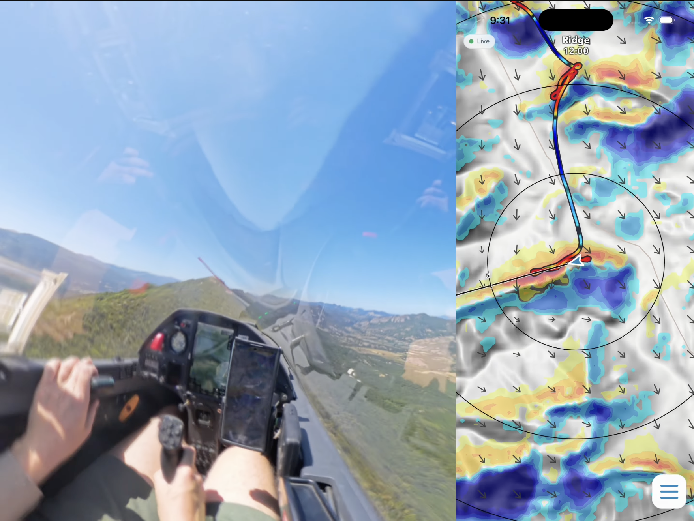
SkySight
· SkySight
SkySight launches the highest-resolution soaring forecast ever
SkySight’s new 100-metre Wind and Ridge Forecast model has left beta and is now generally available across all SkySight forecast regions.
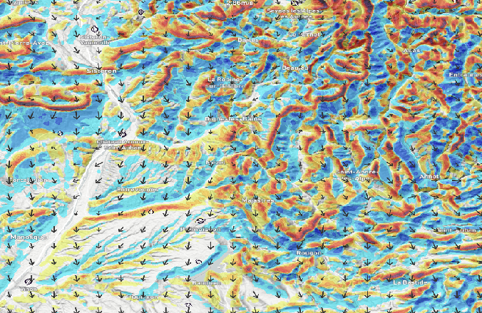
What is weather-model resolution?
Weather-model resolution is a measure of the distance between the forecast points within a weather model. High resolution models have very many forecast points, on the peaks, in the valleys and all the way up the slopes, whereas low resolution models may end up with one forecast point either side and not even see the mountain exists!
The more complex the topography, the more important model resolution is. Broad-scale winds can be transformed over distances of only a few hundred metres by individual ridges, saddles, passes and valleys. A conventional weather model may capture the overall situation while still missing the local detail that determines whether a slope produces lift, sink, turbulence or sheltered air.
It is important to note a model has resolution in the 3rd dimension too, often forgotten about, but critically important for soaring forecasts to produce accurate cloud and thermal forecasts. We don’t just forecast for the ground, but for heights aloft as well, although the spacing is usually logarithmic rather than a fixed distance apart, with more layers near the surface.
The new 100m model is designed to reveal that detail. Its elegant, intuitive charts show not only which ridges are likely to work, but also where heavy sink may form, where the flow accelerates through narrow passes, and how it turns, splits or broadens through complex valley systems.
| Model | Resolution |
|---|---|
| SkySight’s thermal models | 1-2km (depending on topography), 75 layers below 20km |
| SkySight’s new wind model | 100m, with 50 layers below 3km AGL |
| ECMWF | 9km, 62 layers below 20km |
| GFS | ~20km, 88 layers below 20km |
The technology was originally developed for drones, enabling small, battery-powered aircraft to use soaring techniques to extend their range. Ridge lift offered a comparatively predictable and persistent source of energy—more so than thermals or mountain waves, which require more sophisticated sensors and onboard intelligence to exploit reliably.
A very high level of detail was essential. The more precisely the system could locate usable lift in complex terrain, the less battery energy the aircraft would consume and the less intelligence it would require onboard.
Over the past 12 months, SkySight has used its in-house fleet of 48 Blackwell GPUs, supplemented by substantial additional cloud computing capacity, to run computational fluid dynamics simulations of the most complex terrain around the globe, all at grid sizes of 100 metres or lower. The total investment in computing has exceeded €100,000.
These simulations created a training dataset covering wind directions around the full compass, multiple atmospheric stability regimes and different solar-heating conditions.
SkySight then used this dataset to train an AI downscaling model to understand the relationship between a coarse atmospheric forecast and the detailed local flow produced by the terrain. Starting with the output of SkySight’s 900-metre operational weather models, the system estimates how the airflow will be transformed by individual mountain features, producing detailed guidance on a 100-metre grid for near-surface winds, lift, sink and turbulence.
One of the most remarkable results is the model’s representation of highly counter-intuitive flow patterns familiar to experienced mountain pilots.
These include lee-side recirculation, where near-surface air can be drawn upslope on the sheltered side of a ridge beneath the stronger flow passing over the top; flow splitting, where winds turn in opposite directions after reaching a T-shaped valley junction; and calm, stratified layers on valley floors beneath strong ridge-level winds.
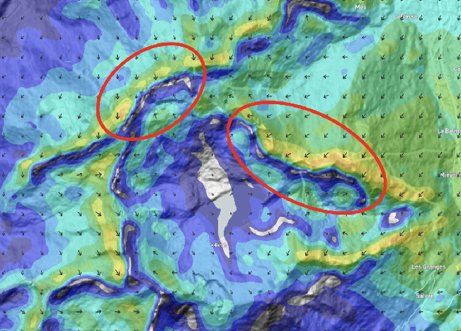
These structures can be difficult to infer from a conventional forecast, but are critically important to a pilot flying in the most complex terrain.
We believe the Ridge Forecast will give pilots a new way to understand difficult terrain, make better tactical decisions and explore some of the world’s most challenging and rewarding soaring environments.
It identifies opportunities for finding lift in unexpected locations, but perhaps its most important contribution is showing where the air is likely to descend violently. By making strong sink, rotor-prone areas and other hazardous terrain-induced flows visible before a pilot commits to a route, it can help them choose a safer range-crossing point, preserve greater terrain clearance or identify a safer escape route while options remain available.
For paraglider and delta wing pilots, the importance of an accurate ridge forecast is even more significant than for sailplanes, having less capacity to escape sink and transition from a ridge that unexpectedly does not work.
During development, we backtested the Ridge Forecast against several historical accidents involving strong-wind conditions in the Alps. In every case tested, it clearly resolved the dangerous local airflow around the accident site, while the contemporary lower-resolution models used for comparison missed or substantially smoothed those conditions.
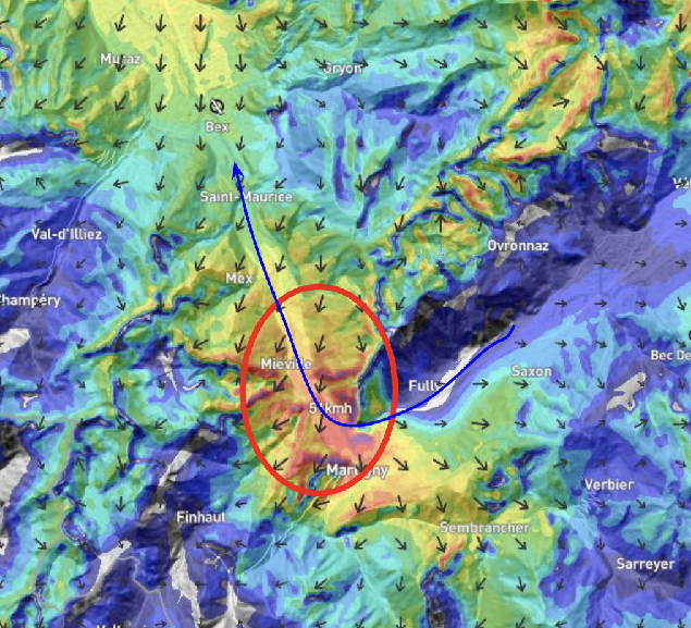
No forecast can make mountain flying safe by itself, but the Ridge Forecast can expose hazards that were previously difficult—and sometimes impossible—to see in conventional guidance.
When SkySight introduced its first in-flight wave charts in 2017, the release was met with skepticism from some elite wave glider pilots. That began to change when less experienced glider pilots started completing substantial wave flights by “following the red line.”
What initially seemed unconventional has since become commonplace. In the background of photographs from wave flights around the world, SkySight charts are now a familiar sight on glider cockpit screens.
We believe the Ridge Forecast will be an even bigger step, helping pilots understand and explore some of the most challenging and magical flying environments on Earth.
So far, we have only scratched the surface of what is possible. SkySight is continuing to expand its computing capacity and refine its AI forecast models, targeting higher fidelity, lower latency and—most critically—a very significant forthcoming improvement in the assimilation of real-time observations.
The new Ridge Forecast is available now in SkySight for pre-flight planning and, most significantly, in flight through the new SkySight Inflight app and WeGlide Copilot. Support is also coming soon to SeeYou Navigator and LX9000 devices. We are open to integrating with other commercial partners too!